
On this page:
Registrar-General's Office (RGO) Library closure at the DELWP Laverton site
On 19 September 2022, the library comprising the records of general law land, located at DELWP’s Laverton site, was permanently closed to the public. All records will be transferred to the Public Record Office Victoria (PROV).
The closure is essential for the preservation and transfer of permanent state records. The record sets that are accessed to conduct general law land searches were digitally converted in 2019. Since January 2022, the digitally converted records have been available and accessible at the PROV Reading Room.
In future, all general law land searching will need to be conducted at the PROV Reading Room at the Victorian Archives Centre, 99 Shiel Street, North Melbourne. The hard copy records will be available to order and view at the PROV once the transfer project has been completed later this year.
There is currently a requirement to make an online booking to access the Reading Room at PROV. Appointments to access the RGO Library records can be booked online through the PROV website www.prov.vic.gov.au
Surveys supporting plans under the Subdivision Act - clarification
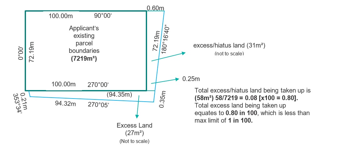
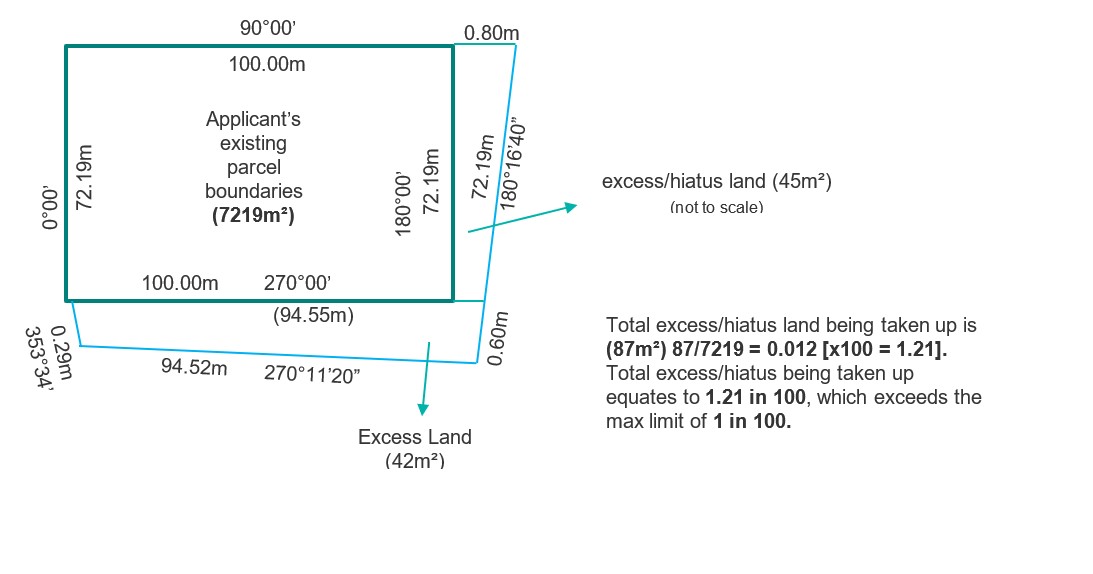
In August 2021, Land Registry Services (LRS) issued Customer Information Bulletin (CIB) 213 which included a reminder to customers that surveys supporting plans of subdivision or consolidation, and boundary plans, must not attempt to amend parcel boundaries by taking up significant amounts of occupied excess land.
CIB 213 introduced a guideline to limit the amount of excess land that can be included within parcel boundaries in a plan under the Subdivision Act 1988 (Subdivision Act). A ratio of ‘1 in 100’ has been set as a limit of the total area of excess land which can be taken up in a plan under the Subdivision Act. See examples below for further detail.
If the area added by adopting mature occupation will result in an increase in the area within the parcel boundaries by more than ‘1 in 100’, it should be addressed by an appropriate amendment application under the Transfer of Land Act 1958 (TLA).
Please note that an amended boundary taking up excess land must accord with mature occupation. A parcel boundary cannot be created solely to match up with the permitted ‘1 in 100’ increase in area unless it accords with occupation or a previously defined parcel boundary.
Parcel boundaries that adopt:
- Crown boundaries; or
- common boundaries with approved abutting surveys where it can be shown that they define parcel boundaries.
are not subject to the ‘1 in 100’ guideline and can continue to be adopted in plans under the Subdivision Act.
All survey-based dealings including plans of subdivision or consolidation and boundary plans should be supported by a comprehensive surveyor’s report justifying any differences to existing plan boundaries.
Acceptable –Where the total area of excess/hiatus land is less than a 1 in 100 ratio
Unacceptable –Where the total area of excess/hiatus land exceeds the allowable limits of a 1 in 100 ratio.
Overlay diagram requirements
Provision of overlay diagrams for ALL plans under the Subdivision Act (except a plan of consolidation) involving Not in Common Ownership (NICO) folios
In April 2021, LRS asked surveyors to provide overlay diagrams for plans under the Subdivision Act that subdivided existing NICO folios (see CIB 210). The provision of these overlays has significantly reduced examination time.
LRS now requires overlay diagrams for all plans under the Subdivision Act (except plans of consolidation) that create new NICO folios.
In complex cases, a spreadsheet can further support the overlay diagram by identifying the parent folio(s) of the Register for the new parcels.
Before the lodgment of the plan under the Subdivision Act and subsequent transfer(s), the overlay diagram and spreadsheet should be provided to the lodging party for the plan and transfer(s). If there is a different lodging party for the transfer(s), they too should be provided with the overlay diagram and spreadsheet before lodgment. It is the responsibility of the lodging party for the transfer(s) to ensure that the correct NICO folios are identified in the transfer(s).
A new document type has been created in SPEAR for this requirement. Please upload the NICO overlay diagram under ‘Add NICO/Encumbrance Overlay Diagram’. Any accompanying spreadsheet can also be uploaded under this document type.
This requirement takes effect from 1 November 2022. Plans lodged without overlay diagrams after this date will be requisitioned during examination.
An example of this overlay can be found in the What is a NICO? guide found here.
Provision of overlay diagrams for encumbrances as to part
LRS also requires that surveyors provide an overlay diagram (like those provided for plans involving NICO folio(s)) for encumbrances ‘as to part’.
This request is for any plan under the Subdivision Act where existing encumbrances (covenants, restrictions, caveats, etc.) affect part of the land in the plan.
The overlay diagram will help identify which new folio(s) are affected by the encumbrance(s) as to ‘whole’ or ‘part’.
As with NICO overlay diagrams, it is important that the overlays are provided to the lodging party prior to lodgment.
Please upload encumbrance overlay diagrams under ‘NICO/Encumbrance Overlay Diagram’ in SPEAR.
Additional information on the Abstract of Field Records (AFR)
As LRS transitions to digital ways of working, existing practices have been reviewed. A past practice has been for the Registrar to add information to the AFR to aid future users.
The Registrar, in consultation with the surveying industry, will no longer add information to the AFR.
LRS recommends that additional information be added to the AFR by the LS to facilitate faster examination.
The following information can be added:
- comparisons (i.e., T/S, T+ or T-)
- the same alignment or adopt corner
- identifying the original survey for reference marks or pegs
- the relationship between survey marks
- noting which previous surveys have been used.
Surveyor’s Reports requirements
As outlined in CIB 214, LRS requires detailed survey information and will requisition if comprehensive information is not provided. A comprehensive Surveyor’s Report must address in detail the re-establishment of the parcel and connections to adjoining surveys. The provision of a clear and comprehensive Surveyor’s Report is crucial to minimising requisitions and ensuring timely registration of plans under the Subdivision Act and survey-based application under the TLA.
For further information please refer to:
CIB 214: https://www.land.vic.gov.au/land-registration/customer-information-bulletins/2021/214
Practice Directives: https://www.land.vic.gov.au/surveying/cadastral-survey/practice-directives
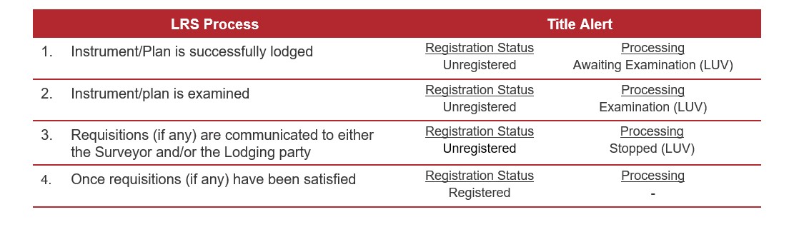
Improved transaction tracking
Changes have been made to assist customers to better understand the status of a lodged instrument/plan.
Once examination is complete, the instrument/plan will either be registered/recorded or a requisition will be issued to the surveyor, the lodging party or to both.
If a lodging party has a property transaction alert set up through LANDATA or through an information broker they will receive alerts as the case progresses.
More information about subscribing to alerts can be found here.
Guide to Dealing Requirements
Dealing Requirements have been introduced to enable a more streamlined lodging and examination process.
LUV has published a ‘Guide to Dealing Requirements’ available through the Fees, Guides and Forms page of land.vic.gov.au. Dealing requirements apply to instruments lodged using an Electronic Lodgment Network (ELN), except for the SPEAR ELN.
If additional information is required to support registration or recording of an instrument, ELN Subscribers must specify in the Lodgement Instructions the appropriate Dealing Requirement.
Customers are encouraged to refer to the Guide when preparing to select a Dealing Requirement prior to lodging an instrument. The Guide sets out the various Dealing Requirements and the transaction types to which they apply.
To view the guide visit the Fees, Guides and Forms page on the Land.Vic website.
Contact us
For location and contact details, please go to www.land.vic.gov.au/contact-us
Page last updated: 09/01/24